Morning edition · Tuesday, 27 October 2026
Athens had a month's rain six times over, and the drains got the bill
Storms turned streets west of the capital into rivers on Monday, the fourth flood alert of an unusually wet Greek October. Another low arrives on Wednesday.
Violent storms hit the Athens region on Monday. Floodwater carrying debris ran through the streets of Mandra and the seaside village of Porto Germeno, west of the capital, and some areas recorded as much as 40 millimetres of rain in an hour1. No injuries were immediately reported1.
The station network of the National Observatory of Athens counted 104 mm at Ellinikon, on the city’s southern coast, over Sunday and Monday up to 18:00, and 133 mm at Amoni Sofikou in the north-eastern Peloponnese, the country’s highest total up to 17:502. This is the fourth time this October that parts of Greece have been at risk of flooding3; earlier floods hit Crete, Evia, Rhodes and Argostoli on Kefalonia1.
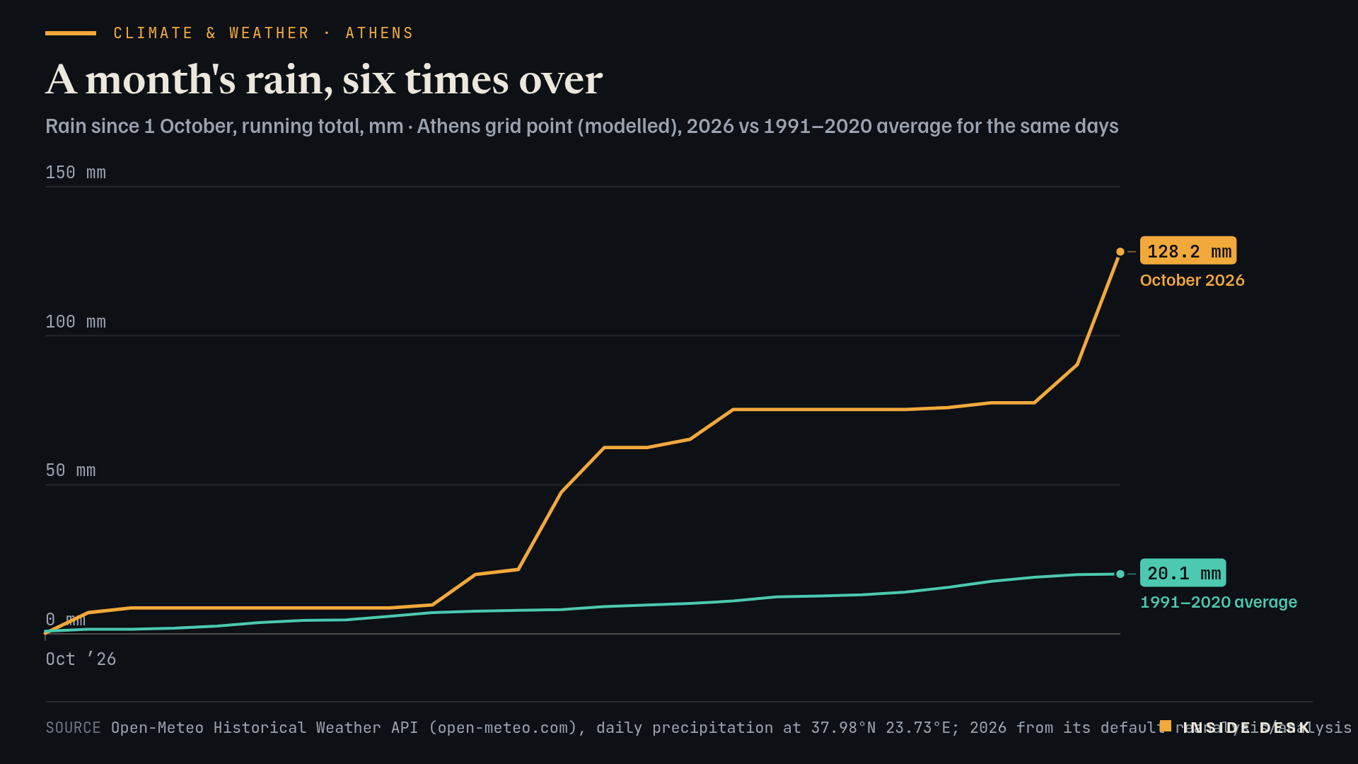
Line chart of modelled rainfall at an Athens grid point, running total from 1 October. In 2026 the total stays below 10 mm until 10 October, jumps to 62.5 mm by 14 October, reaches 77.5 mm by 24 October and ends at 128.2 mm on Monday 26 October 2026, the latest value. The 1991–2020 average for the same days climbs slowly to 20.1 mm by 26 October.
Source Open-Meteo Historical Weather API (open-meteo.com), daily precipitation at 37.98°N 23.73°E; 2026 from its default reanalysis/analysis blend, 1991–2020 average from ERA5 (Copernicus/ECMWF); desk running totals; retrieved 27 Oct 2026 · Open-Meteo data CC BY 4.0. Modelled grid values, not station readings; local stations recorded more.. Figures as reported by the named organisations; facts cited with attribution.
Data (CSV) · SVG · PNG

Latest values as a table
| Date | October 2026 | 1991–2020 average |
|---|---|---|
| 2026-10-21 | 75.3 | 14 |
| 2026-10-22 | 75.9 | 15.6 |
| 2026-10-23 | 77.5 | 17.6 |
| 2026-10-24 | 77.5 | 19 |
| 2026-10-25 | 90.4 | 19.9 |
| 2026-10-26 | 128.2 | 20.1 |
How unusual is that? A modelled grid point over central Athens puts the rain since 1 October at 128.2 mm, against a 1991–2020 average of 20.1 mm for the same 26 days4. Desk arithmetic: more than six times the usual amount. Model grids smooth out cloudbursts, so local gauges read higher; the shape of the month is the point, not the decimal.
Mandra is not a random name. Flash floods there killed 24 people in November 20171. What has changed since is mostly invisible: stream beds cleared, culverts widened, warnings sent to phones. Monday’s floods without reported injuries are a small receipt for that work, not proof that it is finished.
The weather is not done. A meteorologist told iefimerida.gr that “another, stronger low-pressure system from central Europe” will bring rain again on Wednesday, locally heavy, across almost the entire country, with bad weather into Thursday before it eases on Friday1. If you are travelling to Greece this week, check the civil-protection warnings before the ferry timetable.
What to watch
- Wednesday and Thursday: a deeper low from central Europe is expected to bring heavy rain to almost the whole country, easing on Friday, according to a Greek meteorologist1.
- Whether the western suburbs' drainage works, the dull kind of climate adaptation, hold for a second round.
Adaptation is not a summit communiqué. It is a culvert someone cleaned before it rained.
Sources
- Storms Turn Streets Into Rivers Around Athens, More Heavy Rain Forecast — iefimerida.gr, 26 Oct 2026, 13:19 (Athens).
- Ισχυρά κατά τόπους φαινόμενα κατά το διήμερο Κυριακή 25 – Δευτέρα 26 Οκτωβρίου 2026 — National Observatory of Athens / meteo.gr, 26 Oct 2026, 19:00 (Athens).
- Typhoon Champi declared strongest storm of year so far — The Guardian (MetDesk), 26 Oct 2026.
- Historical Weather API, daily precipitation, 37.98°N 23.73°E — Open-Meteo (ERA5, Copernicus/ECMWF), retrieved 27 Oct 2026, 05:20 CET.
Every figure in this piece traces to a source above or to the desk’s own arithmetic on those sources, marked as such. Quotations are short and attributed. Spot an error? Write to the desk; corrections are logged on the method page.
Commentary for information only. Not investment, legal, tax, medical or political advice. Not an offer or solicitation. Analysis may be incomplete or wrong. Charts show published public data, not a trading feed; binding numbers live with the institutions that publish them.