Morning edition · Wednesday, 11 November 2026
323.8 mm in 12 hours on a Madeira hillside, 84 call-outs, and a mainland that shut its schools before the first gust
Charles reached Madeira first and left numbers, not legends. The mainland gets its turn today. The machinery that matters is already switched on: warnings with start times, closed classrooms, airports telling you to ring the airline.
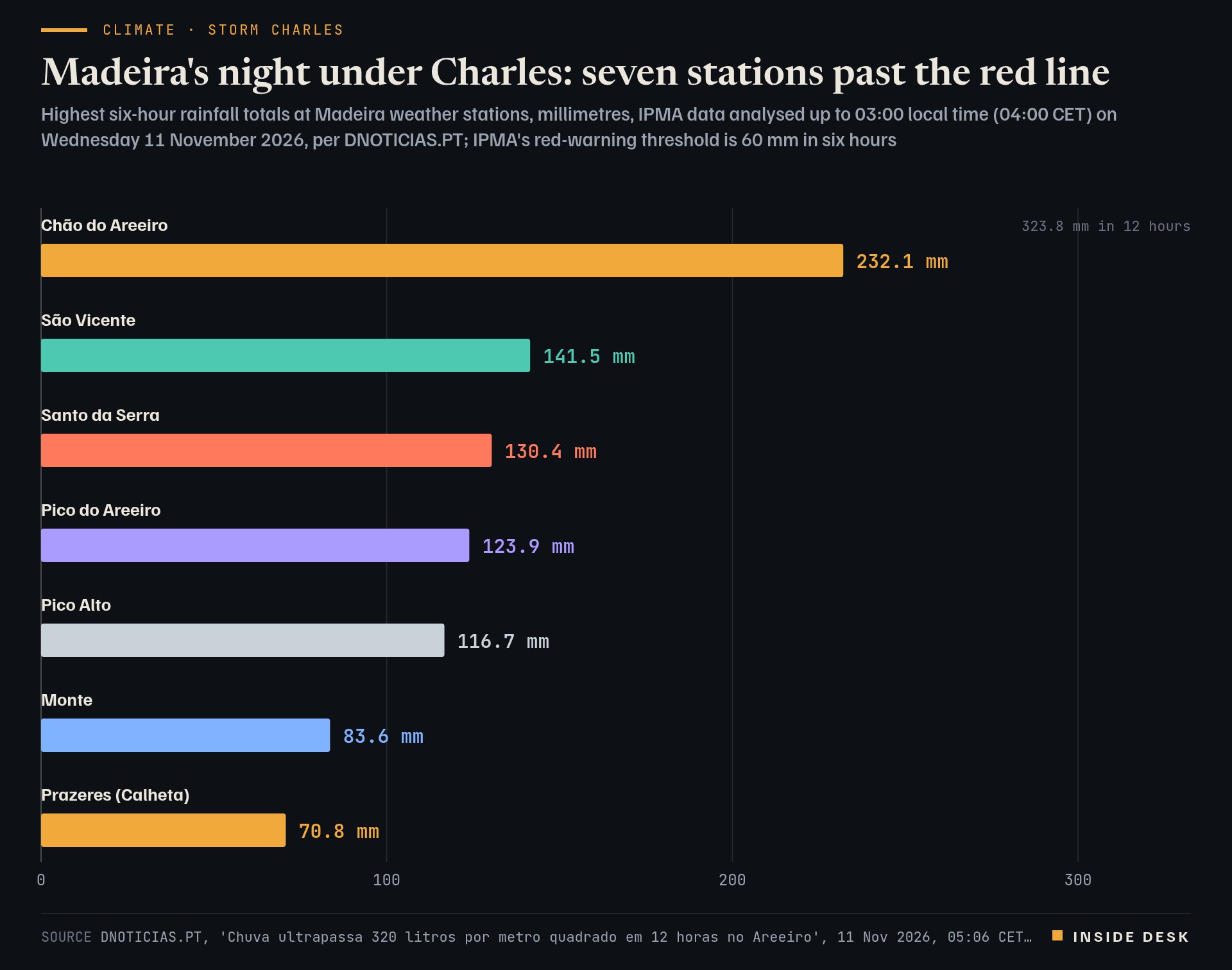
In Portugal, Madeira got Storm Charles first, and it got it at night. By 03:00 local time (04:00 CET) the weather station at Chão do Areeiro, high above Funchal, had collected 323.8 litres of rain per square metre in 12 hours, according to IPMA data analysed by the island’s newspaper DNOTICIAS.PT1. In the last six hours of that window it caught 232.1 mm, almost four times the 60 mm in six hours that triggers a red warning1. Twice the station logged close to 50 mm in a single hour: 49.6 mm at 01:00 and 48.9 mm at 03:00 local time, both above the red line of 40 mm an hour1.
It was not one station. Seven passed the six-hour red threshold, from São Vicente on the north coast at 141.5 mm to Prazeres in Calheta at 70.8 mm1.
Bar chart of the highest six-hour rainfall totals at seven Madeira weather stations during Storm Charles, IPMA data up to 03:00 local time (04:00 CET) on 11 November 2026, per DNOTICIAS.PT: Chão do Areeiro 232.1 mm, São Vicente 141.5 mm, Santo da Serra 130.4 mm, Pico do Areeiro 123.9 mm, Pico Alto 116.7 mm, Monte 83.6 mm and Prazeres in Calheta 70.8 mm. All seven are above IPMA's red-warning threshold of 60 mm in six hours. Chão do Areeiro also recorded 323.8 mm in 12 hours.
Source DNOTICIAS.PT, 'Chuva ultrapassa 320 litros por metro quadrado em 12 horas no Areeiro', 11 Nov 2026, 05:06 CET, citing IPMA station data analysed up to 03:00 local time (04:00 CET); provisional observations, not a final storm total; retrieved 11 Nov 2026 · reported figures. Figures as reported by the named organisations; facts cited with attribution.
Data (CSV) · SVG · PNG

Latest values as a table
| Value | |
|---|---|
| Chão do Areeiro | 232.1 mm |
| São Vicente | 141.5 mm |
| Santo da Serra | 130.4 mm |
| Pico do Areeiro | 123.9 mm |
| Pico Alto | 116.7 mm |
| Monte | 83.6 mm |
| Prazeres (Calheta) | 70.8 mm |
The wind was strong but, by the numbers, short of the worst. The highest gust before midnight was 128 km/h at Chão do Areeiro at 22:30 local time (23:30 CET), with 126 km/h ten minutes later at Caniçal and 102 km/h at the airport in Santa Cruz2. None of those crossed the red-warning threshold for wind, which in Madeira is set above 130 km/h2.
What the night cost, in call-outs. By 03:00 local time the regional civil protection service had counted 84 incidents3. Floods led with 25, then 16 landslips and 11 fallen trees3. Santa Cruz (27) and Machico (23) accounted for 50 of the 84; Funchal had 113. Desk arithmetic: that is about 60% of all incidents in two neighbouring municipalities on the island’s east side. A high-voltage cable came down and cut power in Santa Cruz, Machico and Santana; crews from the island’s electricity company worked through the night and, the paper reports, supply has since been restored4.
That is the useful part of a storm story, and it is never the dramatic part. Somebody counts the incidents. Somebody puts a lorry and a chainsaw on the road at three in the morning. Somebody climbs a pole in the rain.
The mainland’s turn. IPMA’s warnings, last updated at 22:23 CET on Tuesday, put Beja, Faro and Setúbal on red for wind from 09:00 to 21:00 local time (10:00 to 22:00 CET), and Évora, Leiria, Lisboa, Portalegre and Santarém on red from 12:00 local time (13:00 CET)5. The text is the same for all eight: gusts up to 120 km/h, up to 140 km/h in the most exposed places5. Rain has its own red layer for Lisboa, Setúbal, Beja and Faro from 10:00 CET, and for Leiria, Santarém, Portalegre and Castelo Branco from 13:00 CET5. IPMA’s Tuesday bulletin said the centre of the low was most likely to pass between Sines and Cabo Carvoeiro, with “elevada incerteza” (high uncertainty) about track and strength, rain that could exceed 100 mm in 24 hours in places and waves that could reach 13 metres at their maximum south of Cabo Raso6.
The state did its part before the first gust. The government kept mainland Portugal on a state of alert for all of Wednesday and closed schools and non-essential public services8. Parks, gardens and woods are off-limits because of falling trees, and so are the coast, riverbanks and flood-prone areas8. The airport operator ANA told Lusa that operations at Lisbon, Faro and Madeira would be constrained, with cancellations expected, and asked passengers to check with their airline before setting off7. On Tuesday the grid operator E-Redes reported faults that left about 2,000 customers without power, mainly in the south8.
What this means for you. If you are in Portugal or flying there today, the instruction is boring and correct: ring the airline, stay off the seafront, keep a phone charged. If you are not, the lesson travels anyway. A good warning has a start time, an end time, a threshold and a list of what closes, published before the event by institutions that will be told on Thursday they overreacted. Let them be told.
What to watch
- IPMA's red wind warnings on the mainland: Beja, Faro and Setúbal from 10:00 CET, Évora, Leiria, Lisboa, Portalegre and Santarém from 13:00 CET, all until 22:00 CET5.
- Red rain warnings for Lisboa, Setúbal, Beja and Faro from 10:00 to 19:00 CET, and for Leiria, Santarém, Portalegre and Castelo Branco from 13:00 to 19:00 CET5.
- Waves of 5 to 7 metres off the south-west coast this afternoon, with maximum heights of up to 13 metres, IPMA says6.
A storm is measured in millimetres at night and judged in open schools on Friday.
Sources
- Chuva ultrapassa 320 litros por metro quadrado em 12 horas no Areeiro — DNOTICIAS.PT, 11 Nov 2026, 05:06 CET.
- Vento já soprou a 128 km/h no Chão do Areeiro — DNOTICIAS.PT, 11 Nov 2026, 01:41 CET.
- Santa Cruz e Machico concentram 50 das 84 ocorrências da tempestade — DNOTICIAS.PT via SAPO, 11 Nov 2026, 04:06 CET.
- Queda de cabo de alta tensão provoca falhas de electricidade — DNOTICIAS.PT, 11 Nov 2026, 04:59 CET.
- Avisos Meteorológicos (SAM), versão HTML — IPMA, updated 10 Nov 2026, 22:23 CET.
- Depressão CHARLES - Continente e Madeira - Comunicado nº2 — IPMA, 10 Nov 2026, 18:07 CET.
- ANA prevê cancelamentos de voos nos aeroportos de Lisboa, Faro e Madeira (Lusa) — DNOTICIAS.PT, 10 Nov 2026, 18:43 CET.
- Storm Charles causes flooding, power outages in Portugal — Xinhua, 10 Nov 2026, 19:54 CET.
Every figure in this piece traces to a source above or to the desk’s own arithmetic on those sources, marked as such. Quotations are short and attributed. Spot an error? Write to the desk; corrections are logged on the method page.
Commentary for information only. Not investment, legal, tax, medical or political advice. Not an offer or solicitation. Analysis may be incomplete or wrong. Charts show published public data, not a trading feed; binding numbers live with the institutions that publish them.