Morning edition · Wednesday, 28 October 2026
Two storms, 829,400 reconnections, and now the fog
Austen and Boelo have moved on. What is left in Britain is a reconnection ledger, a soaked Highland glen and a forecast that swaps wind for murk.
Britain’s stormy week is ending the way storms usually end: with a list. Storm Austen came through the south, Storm Boelo through the north and west, and an unnamed low followed on Tuesday1. The Met Office’s provisional figures give Austen a top gust of 69 knots on the Isle of Wight and Boelo an observed pressure of 948.1 hPa, the deeper of the two1. Austen’s central pressure fell by about 30 hPa in 24 hours, which meets the definition of explosive cyclogenesis, a “weather bomb”1.
The useful number, though, is the dull one. By 09:00 CET on Tuesday the Energy Networks Association said 829,400 customers had been reconnected and 7,800 were still without power in Great Britain2. On Sunday afternoon it had been 161,4002. Engineers did that work in winds that, for stretches of Sunday, made it unsafe to climb up the infrastructure to fix faults2. A man died near Castle Douglas when a tree fell on him on Sunday morning3; the reconnection ledger does not undo that, but it is the part of the story that was within anyone’s control.
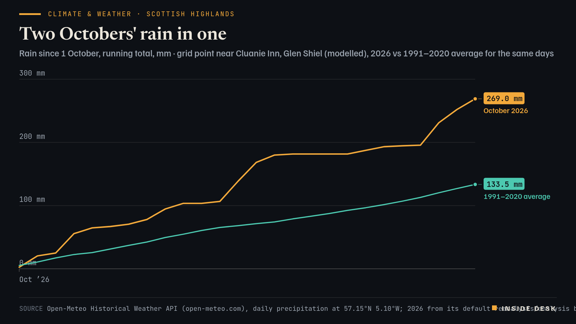
The rain is the other ledger. Boelo dropped 134.4 mm in Ross and Cromarty, and Austen 77.6 mm at Abbey St Bathans in Berwickshire1. More than 130 mm fell at Cluanie Inn in the Highlands3. A modelled grid point near Cluanie puts October’s total to Monday at 269.0 mm, against a 1991–2020 average of 133.5 mm for the same 26 days5. Desk arithmetic: about twice the usual, in one of the wettest corners of Europe.
Line chart of modelled rainfall at a grid point near Cluanie Inn in the Scottish Highlands, running total from 1 October. In 2026 the total passes 100 mm by 10 October, jumps to 180.0 mm by 15 October after a wet 13th and 14th, stays flat through a dry spell to 19 October, then climbs again with Storms Austen and Boelo to 269.0 mm on Monday 26 October 2026, the latest value. The 1991–2020 average for the same days rises steadily to 133.5 mm by 26 October.
Source Open-Meteo Historical Weather API (open-meteo.com), daily precipitation at 57.15°N 5.10°W; 2026 from its default reanalysis/analysis blend, 1991–2020 average from ERA5 (Copernicus/ECMWF); desk running totals; retrieved 28 Oct 2026 · Open-Meteo data CC BY 4.0. Modelled grid values, not station readings.. Figures as reported by the named organisations; facts cited with attribution.
Data (CSV) · SVG · PNG

Latest values as a table
| Date | October 2026 | 1991–2020 average |
|---|---|---|
| 2026-10-21 | 193.2 | 101.6 |
| 2026-10-22 | 194.6 | 107 |
| 2026-10-23 | 195.7 | 113 |
| 2026-10-24 | 231 | 120.3 |
| 2026-10-25 | 252.1 | 127 |
| 2026-10-26 | 269 | 133.5 |
SEPA kept an amber coastal flood risk for the Northern Isles on Tuesday, with storm surge, spring tides and large waves expected to push water over sea walls around high tide4. It expects moderate coastal impacts to reach the Moray Firth and Aberdeenshire on Wednesday, with rain still falling on saturated ground inland4.
Then the pattern turns. The Met Office says a ridge of high pressure is building and should block the most active Atlantic lows, bringing lighter winds and drier weather1. Its warning is that calm brings its own hazard: clear skies, light winds and North Sea moisture favour fog, possibly slow to clear, into early November1. If you are driving in Britain this week, the storm advice changes from “stay away from the coast” to “leave a longer gap”.
What to watch
- Wednesday: SEPA expects moderate coastal flooding impacts to extend to the Moray Firth and Aberdeenshire4.
- Friday and Saturday: the Met Office says a weather front may still bring rain to northern and north-western areas; Halloween could be wet in places1.
- The first insurer or ABI loss estimates for the two storms; none had been published by Monday morning3.
A storm is measured in gusts. Its aftermath is measured in reconnections, and someone has to count them.
Sources
- Deep dive: Turning calmer and foggier after recent storms? — Met Office, 27 Oct 2026.
- Storm Boelo power cut update — Energy Networks Association, update of 27 Oct 2026, 09:00 CET (08:00 UK).
- Storm Boelo: back-to-back storms test claims and cover — Insurance Business UK, 26 Oct 2026.
- Flooding Outlook - Tuesday 27 October — Scottish Environment Protection Agency, 27 Oct 2026.
- Historical Weather API, daily precipitation, 57.15°N 5.10°W — Open-Meteo (ERA5, Copernicus/ECMWF), retrieved 28 Oct 2026, 05:25 CET.
Every figure in this piece traces to a source above or to the desk’s own arithmetic on those sources, marked as such. Quotations are short and attributed. Spot an error? Write to the desk; corrections are logged on the method page.
Commentary for information only. Not investment, legal, tax, medical or political advice. Not an offer or solicitation. Analysis may be incomplete or wrong. Charts show published public data, not a trading feed; binding numbers live with the institutions that publish them.